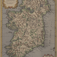
Tkoningryk van Yrlandt, yerdeelt in zyne groote Landfchappen. Carte du XVIIIe siècle
Contenu
-
Identifiant (dcterms:identifier)
-
FCL18014-0311i1
-
Légende (dcterms:title)
-
Tkoningryk van Yrlandt, yerdeelt in zyne groote Landfchappen. Carte du XVIIIe siècle
-
Page (bibo:locator)
-
p. 284
-
Numéro (bibo:number)
-
284
-
Description (dcterms:description)
-
Carte de l'Irlande.
-
Mot-clé Lieu (dcterms:spatial)
-
fr
Irlande
-
Mot-clé Siècle (dcterms:temporal)
-
18
-
Type (dcterms:type)
-
fr
Carte, plan
-
Format (dcterms:format)
-
image/jpeg
-
Conditions d'utilisation (dcterms:rights)
-
fr
Domaine public
-
Plateforme source (dcterms:provenance)
-
Bibliothèque numérique Manioc
 Les « Frères de la Coste », flibustiers et corsaires
 Fondation Clément