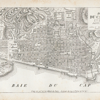
Plan de la ville du cap français et de ses environs dans l'ile de St-Domingue
Contenu
- Identifiant (dcterms:identifier)
- SCH130080207i1
- Légende (dcterms:title)
- Plan de la ville du cap français et de ses environs dans l'ile de St-Domingue
- Extrait de (dcterms:isPartOf)
-
 Dictionnaire géographique et administratif universel d'Haïti illustré... ou Guide général en Haïti : avec gravures, illustrations, plans, cartes et vues dans le texte, et une carte coloriée de l'île d'Haïti. Tome 1, A à F
- Page (bibo:locator)
- entre p. 172 et 173
- Numéro (bibo:number)
- 172
- Description (dcterms:description)
- Plan détaillé du Cap Français
- Mot-clé Lieu (dcterms:spatial)
- fr Haïti
- Type (dcterms:type)
- fr Carte, plan
- Format (dcterms:format)
- image/jpeg
- Conditions d'utilisation (dcterms:rights)
- fr Domaine public
- Provenance (dcterms:rightsHolder)
-
 Bibliothèque Schœlcher
- Plateforme source (dcterms:provenance)
- Bibliothèque numérique Manioc
- URI (bibo:uri)
- http://www.manioc.org/images/SCH130080207i1
Ressources liées
| Titre | Classe |
|---|---|
 Dictionnaire géographique et administratif universel d'Haïti illustré... ou Guide général en Haïti : avec gravures, illustrations, plans, cartes et vues dans le texte, et une carte coloriée de l'île d'Haïti. Tome 1, A à F Dictionnaire géographique et administratif universel d'Haïti illustré... ou Guide général en Haïti : avec gravures, illustrations, plans, cartes et vues dans le texte, et une carte coloriée de l'île d'Haïti. Tome 1, A à F |
Texte |

